Showing posts with label Snake River. Show all posts

Monday, December 16, 2013

Owyhee Chills No Frills


December 16 2013

Our last 50-mile endurance ride of the season was November 9th, but it's never too late to look back at it.

We rode the same trails, by the Snake River, around Wild Horse Butte, over the Oregon Trail… but it never gets old, and it looks different aboard different horses. And the golden autumn light made the trails spectacular as ever.

And, I rode 2 different horses on each loop. Normally that's against the rules in endurance riding, but this was special extenuating circumstances. Both horses were technically Sunny (John's beloved mare), but Loop 1 was Sunny Dink and loop 2 was Sunny Super Endurance Horse!

Above:
Long shadows over the blue Snake River


Sunny and I rode with Steph on Rhett, Amanda on Chant. They were also Dinks the first loop, and Super Endurance Horses the second loop!


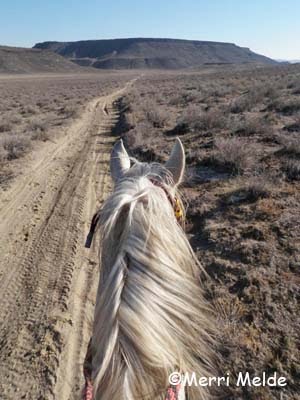
Sunny, Super Endurance Horse (loop 2, obviously!) headed for Wild Horse Butte


This spot where we first turn along the Snake River is always stunning!


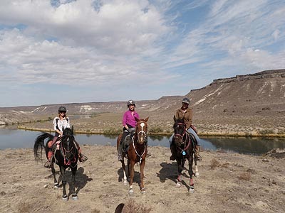
Our regular posing spot above the Snake. We always have time to stop for photos!


Sunny and me by the Russian Olives by the Snake.


Travelling the Oregon Trail


The Raven and Sunny, relaxing after their ride!

Read more on this 2-horse ride here:
http://merritravels.endurance.net/2013/11/owyhee-chills-no-frills-three-dinks.html

Wednesday, October 16, 2013

Owyhee Harvest Moon - Day 2


Wednesday October 16 2013

I've done these loops many times - to Regina's place for a vet check, around Wild Horse Butte and along the Snake River and back to Regina's for a vet check, then back home. The scenery never gets old.

Batman and The Raven and I finished Day 2 of the Owyhee Harvest Moon endurance ride on these familiar trails.

Here are a few pictures from the day:

up top:
We had a whole lotta water here from a flash flood about 5 weeks ago. The water rearranged many trails and hills and washes. Here a good deal of water sat for a while until the ash-y mud dried and cracked.


Alan joined Steph and Amanda and me for part of the ride. The Snake River is always pretty at this spot!


Me, Amanda and Steph posing at our regular spot above the Snake River.


Batman is checking behind him, to see if there is anybody that needs saving.


Riding an old canal near the Snake River. The only thing Russian Thistle - aka tumbleweeds - is good for is the pretty reddish color it turns in the fall. Other than that - nada.


Batman likes a variety of food at vet checks. He tries food from every dish that is near him. He was even eyeing my hamburger!


Batman and The Raven finish another ride together!

Wednesday, May 22, 2013

Snake River Petroglyphs


May 22 2013


Some 32,000 years ago, Lake Bonneville formed, covering most of northwestern Utah (the Great Salt Lake is a remnant). About 15,000 years ago, it broke out of its natural dam near present-day Pocatello Idaho, creating the Bonneville Flood - possibly the second largest ever on the planet. For 8 weeks it flooded out at maximum, carving canyons and falls, ripping out huge, car-sized boulders from canyon walls, and depositing them along the river.

Today, geologists call these big boulders "melon gravel" because of their resemblance to big watermelons. Rolled and smoothed and polished and tossed around by the great powerful floodwaters, some of these boulders became canvases for Native American art.

By 12,000 years ago, humans were living on the Snake River Plain. (The earliest evidence from a cave near Dietrich, Idaho, are tool flakes and a basalt knife 14,500 years old.) The petroglyphs carved on many of the tens of thousands of boulders along the Snake are evidence of their early habitation. Many petroglyphs are probably from the Early Archaic (5000 to 7800 years ago) and Middle Archaic periods (1000-5000 years ago), though most are from the Late Archaic period (340 to 1000 years ago). Many of the petroglyphs along the Snake resemble Shoshone Indian art found in California and Nevada.


The Snake River petroglyphs can be accessed by following a maze of dirt roads, or knowing where the locals access trails. We used a shortcut starting up on the flats, taking a steep cliff trail down to the river basin.


Petroglyphs are scattered on boulders for miles along the Snake River (you might be interested in the book Understanding Meaning and Purpose of Rock Art, by D Russel Micnhimer).

 
On the north side of the Snake a couple of miles upstream from where we rode is Celebration Park, Idaho's only archaeological park. On the south side, downstream on BLM land, a large collection of the rock art is grouped together, and is well-preserved, likely because of its non-advertised, not-so-easily accessible location.


We looped through the art gallery, both horses and humans contemplating the meaning of the art, and wondering about the people behind the imaginations that created it so long ago.

[slide show here]


or link:
https://picasaweb.google.com/TheEquestrianVagabond/SnakeRiverPetroglyphs5202013


Monday, April 29, 2013

Owyhee Tough Sucker II


Saturday April 27 2013

The Owyhee Tough Sucker II was another fun 50-mile endurance ride with Jose and The Raven! The Tough Sucker I was cloudy, cool, and rainy; Tough Sucker II was sunny, hot, and dusty

The start of dust on the trail


Long morning shadows on the Owyhee desert


The Owyhee mountains in the distance


Water stop for the horses


Jose, with his Elf Eyes, sees something very important off in the distance.


Jose staring off the top of the Hallelujah Rim Trail

Pelvic bone trail marker

Jose snacking on hay at the vet check


The Raven with Jose at the vet check
 

Seth and his draft horse finishing their first LD!
 

Heading out on Loop 2 around Wild Horse Butte by the Snake River

Go Jose!

I might have a hundred shots from this spot, but it never gets old or un-purty, and it's a tradition to pose from here now! With Steph on Rhett

 Nance and Zippy, Wild Horse Butte in the background

Jose looking and Deep Thinking

Laurel and Buffy, Linda and Ted, coming up out of the Birds of Prey Badlands

The trail was quite dusty by day's end!

Conveniently, Carrie had a birthday we celebrated at the ride dinner!

 Many more photos, and stories from both Owyhee Tough Suckers here!

Saturday, May 19, 2012

Snake River Screech Owls


Saturday May 19 2012

I've been lucky enough over the years to have helped with spotted owl research and banding. And I was lucky enough to participate in helping to band screech owls with the Boise district BLM! They take out a handful of people on raptor banding trips throughout the year. I signed up for this one about 6 months ago.

Retired biologist John Doremus started working with raptors for the BLM in 1972, and he was the raptor biologist for the Snake River Birds of Prey National Conservation Area in Owyhee County along the Snake River since it was first designated a Natural protected area in 1993. He started hanging nest boxes and building nesting platforms for raptors, and banding and monitoring the birds; and as the BLM manages this NCA, they continue this raptor banding and monitoring today.

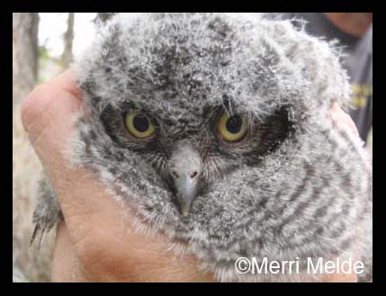
A group of us went to a number of these nest boxes occupied by screech owls along the Snake River. 4 of the 5 boxes were occupied; 3 nests had owlets too young to band (1 week old and 2 weeks old); we banded one nest with 5 young (3 weeks old).

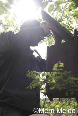
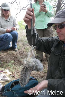
Here's how you catch a screech owl: Greg Kaltenecker from the Idaho Bird Observatory was the Master Raptor bander. He climbed a ladder to the nest box, opened the top, and reached in and removed the adult (presumably) female screech owl and handed her off to one of us;

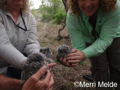
then one by one he reached in and removed the 5 owlets.

When owls are upset or feel threatened, they snap their beaks. All around us were the Snap! Crackle! Pop! of agitated owls. After a while though, as long as you don't make loud noises or make sudden movements, they relax in your hands.

Greg attached a silver federal band, each with a unique number, to the right leg of each owl, then weighed each of them, while Jill recorded the info.


The owlets were sublimely, ridiculously cute, and of course we all posed with our fluffy little treasures before Greg tucked them all snugly back in their nest box, putting mama screech in lastly on top of them.


One day, maybe each of these babies will be sitting on nests of their own along the Snake River.

[slide show here]

Tuesday, March 13, 2012

Good Lord Willing and the Crick Don't Rise


Tuesday March 13 2012

The Owyhee Fandango 25/30/50/60/80/100 is (sort of) around the corner: May 25-27.

We went out on foot and scouted the Whiskey Traverse, a spectacular stretch of trail alongside the Snake river for a mile below the cliffs, among boulders. It was a pretty technical trail which was used during the 2010 Fandango 80 and 100 miler.

We checked to make sure there are clear paths around the boulders, and we found detours around any sketchy spots.

The only thing that would prevent us using it this year, besides a sudden 10,000-year flood which would deposit new boulders along the river, would be if the Snake River rises over the one spot of the trail that drops right down beside the river for about 20 feet. In this case, Steph would cut out this part of the trail and just include the Petroglyphs loop (which is not too shabby itself), and add the mileage on somewhere else.


So, the Good Lord willing and the Crick Don't Rise, the Whiskey Traverse will be part of this year's Owyhee Fandango 80 and 100 mile rides.

[slide show here]

Tuesday, December 13, 2011

Wild Horse Butte: Hoofin' It


Tuesday December 13 2011

We've passed beneath it many times on horseback, its cliffs safeguarding the mysteries above. Why is it called Wild Horse Butte? Who named it? It stands sentinel over the Oregon Trail on its south side, and the Snake River on the north. A large, old weathered cairn marks a point on the northeast rim, visible from far away up and down the Snake.

Did the pioneers name the butte? Did they see wild horses watching them from the cliffs as their slow wagons rolled by? There are rumors of an old spring or lake up on top.

While Jose has carried me enthusiastically around the base of Wild Horse Butte many times, I've often looked up and scrutinized it, searching for a way to hike up to the top that didn't involve ropes and pitons. On our last ride past there, the Owyhee Hallowed Weenies in October, I spied a route.

Carol and I hoofed it there on foot, approaching it from the southwest. We crossed the Oregon Trail that we ride along, and headed up a drainage chute where the cliffs had long given way to a steep but scramble-able path up onto the rim.

300 feet above the flats, we have a grand view of Owyhee: the broad Fossil Creek drainage to the southwest - which sweeps around both sides of Wild Horse Butte into the Snake River, and the snow-kissed Owyhee mountains at its head.

Castle Butte to the east marks the passage of the Snake River from its origins in Yellowstone National Park.

At this height, we are taller than the Canadian geese who fly in formations to the west (here they always seem to be flying west, to some mysterious tropical paradise in the wrong direction).

The blue ribbon of the Snake River splashes a striking vividness among the muted winter desert hues.


We see familiar landmarks in the distance, and from the different perspective of a bird: Fossil Butte, Sinker Creek; the Oregon Trail that leads into the West;

the Bates Creek and Pickett Creek drainages in the far distance. We try to decipher the desert puzzle from above, which hills we ride around, which washes we cross, which rims we follow.

Visitors of the two-legged earth-bound variety up here are probably rare; we startle a 4-legged deer and a canyon wren. The rabbits remain hidden in the sagebrush as we tromp their trails along the circumference of the butte.

It is 3 1/2 miles around the edge of the rim. Evidence that cows occasionally find their way up here are in the old cow pies and the cheat grass that has taken over the top of the butte, as it has most elsewhere in this country (a product of overgrazing).

Down feathers stuck to bushes are evidence of meals that are consumed up here: perhaps the diner was a prairie falcon or a golden eagle from the Snake River cliffs or Castle Butte territories.

When you walk with your own two feet, you get to know a place more intimately, appreciate it more, and start to think beneath the surface layers. Walking the top of Wild Horse Butte, you see hints of layers of sediment - a layer of iron, a layer of shore-sand, a layer of river-washed smooth stones, beneath the volcanic layers.


Looking down on the Snake River makes you wonder what it would have been like to see the creation of the Snake River Canyon, as the water from Bonneville Lake in Utah broke through its natural dam 15,000 years ago and rushed through this once flat desert.

And the more you see on foot, the more questions you come up with. We see scattered quartz crystals on random areas of the butte; why in these particular spots? (We finally default to the Raven explanation: it's the Ravens that place them there as artwork.)

And who built all the cairns on top? Some are small, the one is large and took some effort. Some of them are old, judging by the amount of moss growth on the stones. Are they ten years old? A hundred? The first stone on the bottom laid by pioneers in 1850, and the last stone on top laid by us today?

On the way down, two deer antlers left behind show that we are not the only ones who think this chute up onto the rim is a good way to climb to the top.


From the top, I saw the trails like I've never seen them before. From the trail next time, I'll never see Wild Horse Butte the same way again.


**A footnote:
My friend Karen S corrected me on one incorrect assumption:
"The Snake River Canyon already existed before the Bonneville flood.  The flood scoured out the canyon, maybe deepened it a bit and left it looking more or less like it does now.  The flood did not create a new canyon over flat land."
Thanks Karen!