Showing posts with label exploring. Show all posts

Saturday, November 24, 2018

Exploring Owyhee's Perjue Canyon


November 24 2018

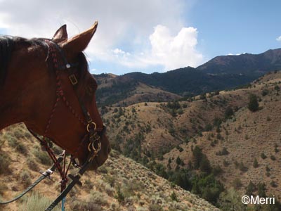
This Owyhee sagebrush flat and canyon had just a bit of a…. cougar-y feel. Not an imminent we're-going-to-get-jumped-on feeling, but… thick brush along the crick, a single path along the bottom of the high-walled canyon, rock shelters and lairs and mini-caves above, the cool stillness of a fall day, pregnant with the feeling of possibility and opportunity springing forth.

And that was before, about 20 minutes into our ride, Karen said, "Did I tell you last time we came here to hike this trail I saw a cougar print?"

Dudley and I had hitched a ride with Leah and her mustang Bear, and Karen and her former endurance horse Rusty, to explore Perjue Canyon in the Little Jacks Creek Wilderness. Rusty charged eagerly ahead on the trail, unafraid of anything (his only nemesis is cows), and Bear followed, completely unflappable (I expect if he ran into a cougar, he'd Stink-eye it away), followed by Dudley. The Dude wasn't nervous, but one time in the canyon he did stop and whip his head around behind him and he studied the brush along the crick a while. Dudley always sees wildlife before I do so I always wait to see what he's spotted; this time he didn't actually see anything. But Dudley knew that here it didn't hurt to check. 

I wasn't nervous, but I've learned over the years, if it feels like cougar country, it is cougar country. Doesn't hurt to keep your eyes peeled at the brush, the rock outcroppings you're riding under, and glance behind you now and then. Cougars aren't particularly numerous out here, but they are here.

While the canyons in the Owyhee country don't have the flair and grandeur of Utah's red canyon country, ours can still be a little bit spectacular, much less traveled, and intriguing to explore, particularly on foot. If there aren't trails down in all of them, there are usually plenty of old two-track roads to get you cross-country and at least above those canyons.

Closer to the cities, the red rhyolite-walled Sinker Canyon can certainly be called spectacular; it's a popular place for ATVs (so if you're going horseback, you want to go mid-week, and preferably when schools are in session), and a side trip on your way to Silver City.

Perjue is further out - a good hour further out, on a good-but-washboard Mud Flat dirt road that is part of a scenic Owyhee Uplands Backcountry Byway over the Owyhee mountains that eventually dumps you out at Jordan Valley, Oregon.

The canyon is named after Frank Perjue, whose old cabin walls still stand near the approach to the canyon. He probably homesteaded cattle (or sheep?) here in the early 1900's, and it was probably his livestock that originally laid the trail that we rode on. Perjue Canyon follows the West Fork of Shoofly Creek.

The Little Jacks Creek Wilderness (over 50,000 acres) is 1 of the 6 wilderness areas in Owyhee County, designated in 2009. BLM, Idaho Trails Association and other volunteer groups worked on developing this trail in Perjue Canyon. It's an out-and-back trail 4 miles down the West Fork of the Shoofly Crick, where it ends at private property (we were hoping for an obvious loop trail, but nothing obvious appeared, but with more exploring, there might be options), and 4 miles back.

At places, cottonwoods crowd the trail, and thick quail bush clusters along the narrowing canyon. We were past the time of golden autumn leaves, but during the height of color, the cottonwoods along the crick must be stunning yellow, and the quail bush deep maroon. And, at the right time of year, you can see bighorn sheep in and above the canyon.

We had a bit of water in the crick that we crossed several times (ice, actually), but the brush looks thick enough that there may be some water puddles year round.

It's an easy day hike for Owyhee hikers (and a BLM picnic area and vault toilet is about a mile down the road), and an easy exploring ride for trail riders. There was enough up and down, and a bit of scrambling over shale at a few places, and long enough to make Dudley sweat, even in the cold, though as endurance riders we wouldn't have minded another 10 miles or so, for the long trailer ride we took to get there.

But it was another cool new checkmark I can put on my Owyhee country map, and Dudley had a good time and a good workout!


Monday, October 22, 2018

Old Explorers*


October 22 2018

This is what endurance horses do between endurance rides

Riding the Rim Trail, we have a long, scenic view down into the Hart Creek drainage. Between the crumbly cliffs of the rim and the crick is a maze of hills and washes, what looks like an old travertine hot spring hill, and a hidden jumble of bentonite** sculptures, the leftovers from a long-ago eroded lake-bed sediment. I call the sculptures the Dragon's Backbone.

Carol and I hiked there once, from the top down. You've got to find the right ridge to climb down, or else you'll lose your footing and slide…. a very long hide-ripping, tumbling way down. 

Finding the Dragon from the bottom up is a game of hide and seek, because one cliff face looks like another, as does one hill from another, and who knows which hidden box canyon the Dragon hides behind?

We managed to catch just a glimpse of a bentonite outcrop on our regular Hart Crick trail, so we angled off cross country, bush-whacking our way to the hidden treasures. Hillbillie Willie was all for this new exploring adventure with his pal August, going places where (possibly) no horse has gone before.

Around behind a hill, the white monster appeared, growing out of the ground as we picked our way toward it, and Willie's eyes bulged in disbelief and wonder. What magic is this!?

We found names carved on one of the white mushroom rocks, some dating back to November of 18… was that really November of 1918???? Or someone modern but totally confused about the date? There were settlers living on this crick a hundred years and more ago; we ride regularly by one of the homesteads built into a hillside.

We ended up discovering deer trails leading us in a winding path (with some steep climbs!) back up onto the rim.

Willie still loves being an explorer, and he was so fascinated by the secret Dragon's Backbone that he decided he wants to be a geologist in his next life.


*Old Explorers is, by the way, a fabulous older movie, if you can get your hands on it

**Bentonite? I don't know for sure, I'm not a geologist. But Hillbillie Willie will be able to tell you for sure in his next life.


Tuesday, July 31, 2012

On the Trail of the Old Gold Miners


Monday July 30 2012

When it gets too unbearably hot in the Owyhee desert, you load up the trailer and head for the hills. A steep twisting road takes us up into the Owyhee Mountains, up the old dirt Silver City stage road. Even though it's graded and well maintained, it sure makes me glad I'm not a stage coach driver back in the gold rush days - and it still makes me a bit nervous with its steep grade and sharp curves. The road deposits us 2500' above the valley floor where it's a delightful 15 degrees cooler, and a hundred years older.

Karen and I ride her horses Rusty and Gil, through the streets of Silver City, 

an old mining ghost town and national Historic district, which produced some of the richest hauls of gold and silver in Idaho's history, and which served as the county seat from the late 1800's to early 1900's.

We successfully explore a new loop on some old back mining roads. We ride past many old mines - adits tunneled into the mountainsides with their white tailings scarring the slopes, and open shafts sunk straight down right on the edge of the roads. 

We ride up alongside a series of tailings and a newly-under-construction road, which are part of the Oro Fino mine, originally discovered in 1863, and now being re-mined. 

Now the Silver Falcon Mining company is sifting through 30,000 tons of tailings they've hauled down from the mines, including the Oro Fino, on War Eagle's flanks. I'd heard they were going bankrupt and so pled for permission to start leaching for minerals. They just won that request. Doesn't say what process they'll use, but the industry standard for leaching gold is cyanide, which is of course toxic to the environment. And people. One can only hope there's no leak in their liners anywhere.

According to one source, the original Oro Fino mine produced $1,800,000; according to another source, it "yielded $2,756,128 in six years, without any considerable cost to its owners." That's at the value of the dollar back then. Silver Falcon expects to recoup 6 million dollars worth of gold and silver from the tailings.

But gold fever hasn't grabbed us, and we're more interested in riding these historical trails, like this steep descent from the War Eagle saddle, and 'discovering' new sights, like this cool old mining shack. 

Note the old outhouse that perched right over the creek (!!! woe to the downhill neighbors!).

The ponies work hard, climbing 1500' to 7600', just 300 feet below the top of War Eagle peak, then scooting and slipping back down the other side, reminding us just how hard the mining days must have been, not just for humans, but for the 4-legged beasts that toiled the roads, making possible the Gold Follies and Dreams of men (and women) of the Idaho Gold Rush days.


[slide show here]

Tuesday, October 25, 2011

City of Rocks: New Trails


Tuesday October 25 2011

Goldseekers. Hunters. Trappers. Wanderers. Adventurers. Flee-ers. Seekers. Hundreds of thousands of pioneers emigrated westward along the California Trail in the early and mid-1800's. The northern branch of the California Trail passes through the old lands of the Shoshone and Bannock Indians, through what is now southern Idaho, and the City of Rocks National Reserve.

Between 1843 and 1882, an estimated quarter million emigrants travelled through the City of Rocks on this trail en route to the West. In 1852 alone, some 52,000 people passed through.


City of Rocks was a landmark for the emigrants, one that inspired wonder and romantic awe, and a form of relief in their long journey from the East:

 Sallie Hester -  August 3, 1849
"Passed some beautiful scenery, high cliffs of rocks resembling old ruins or dilapidated buildings."

Dr. John Hudson Wayman - July 12, 1852: "This City is walled in on every side with towering granite mountains, some peaks shooting athwart the sky like towering domes. While hundreds of piles, peaks, steeples and domes, of all shapes possible in the distance looking like an old dilapidated City"

The Twin Sisters - 2 side-by-side granite spires, one of which is 2.5 billion years old, the other 25 million years old - have been significant throughout recorded human history. The peaks may have had important spiritual significance for the Native Americans. They were a significant landmark for the pioneers travelling the California Trail. Not named "Twin Sisters" by white people until 1848, there were 88 descriptions in 86 pioneer journals comment on them, including Steeple Rocks, Twin Mounds, Twin Buttes, Twin Pyramids at Gate, Two Dome Mountain, and Castle Rocks.


The old California Trail snakes through the Circle Creek valley, surrounded by the unique granite formations that give City of Rocks its name. Emigrant Canyon, through which runs the old Salt Lake Alternate Emigrant Trail and the old Boise-Kelton Stage Route, spills into City of Rocks with a view of the Twin Sisters where it meets the California Trail. Heath Canyon climbs up and over a gentle pass that also drops down to the California Trail and a view of the Twin Sisters (see my stories of our rides over these other trails here).

Perhaps the pioneers also used this new route we rode on Saturday. Maybe they travelled up the valley of Junction Creek, and turned off and camped at Sparks Spring and watered their animals like we did.


Perhaps they picnicked and rested at this giant granite pinnacle like we did.


Maybe they crested this unnamed pass and were amazed at the Twin Sisters that rose into view and guided them like a beacon as they descended to the Salt Lake Alternate trail, as they did for us.


Maybe our awe matched their own.

[slide show here]

Monday, October 24, 2011

City of Rocks: Gold in Them Thar Hills


Monday October 24 2011

There's just something special about riding through Gold.

Gold means the air is crisp and cool. Gold means the light is soft and angled, which only accentuates Nature's artwork. 

Golden aspen leaves on the trees quake and shimmer a welcoming path through the forest.


Fallen golden leaves carpet the paths underfoot,


and sprinkle the creeks with golden glitter.


We had more trails to scout in the City of Rocks National Reserve, where Steph is putting on a 4-day endurance ride next year. Conveniently, it was the peak of the turning of the aspens.

15 miles on Friday led us along paths of gold, through City of Rocks, climbing above the Circle Creek valley


and into the lower reaches of the Albion Mountains. Snow patches from the early winter snowstorm that moved through the Northwest on October 5-6 still basked on sun-sheltered crags to the north, and it had only recently melted in the fir forest we climbed to.

Woman and beast alike savored the scenic ride through the Gold of Autumn.

[slide show here]

Sunday, August 21, 2011

Give Those Cow Ponies Credit


Monday August 21 2011

We've been talking about finding a trail to ride up into the Owyhee Mountains to Burnam Flat from home. Over the years, Steph, Carol, and Regina have ridden up there at different places with some ranchers, but some of it always involved scrambling off trails up some steep slopes, and they don't exactly remember the routes. If you don't know where the gates are, you won't get through, and we tend to like to avoid cliffs.

Regina and I studied maps and Google Earth (I caught Steph's bug - it's addicting when you look at 3D images of mountains and wonder where you can go and how you can get there!), and we plotted some of the cow trails Regina rode with the Joyce Ranch cowboys as they were gathering cattle last fall. You can't always see existing roads on Google Earth (because of the forest), and you sure can't trust the accuracy of the USGS maps - sometimes they show old roads and trails that no longer exist; sometimes they don't show the newer roads that do exist. Regina has a good knowledge of the area, but a lot of that is cross country because that's how the cows go.

I drew our proposed route on the maps: up Fossil Creek and cross to Gerdie Creek where there is a road (Regina rode on it) going up the creek; up out of that drainage, over a saddle to the Sinker drainage, down and along the (? unnamed?) Southeast Fork of Sinker, turn up the South Fork of Sinker, and hit Scotch Bob Road. If we were lucky.

It was maybe 7 mountain miles in to Scotch Bob Road, so either 7 miles back out, or find another route.

Scotch Bob connects to the Silver City Road (if there are no locked gates; an old mining tunnel is being reopened, so who knew if public access was cut off); roads off Scotch Bob should eventually reach Silver City, though that would take other days of exploring.

We cheated a bit by hauling the 6 miles of boring straight bumpy rocky road up to the base of the mountains to start out on the route we we picked out.

Unloaded the horses - and realized I forgot the maps.


Well.

Regina thought she had most of the trails in her head. We wouldn't get lost, and I at least had a GPS to take waypoints if we had to navigate back somewhere, and to see later where we'd gone on the maps.


We started at the corrals on Fossil Creek. The ruins of an old cabin mark the spot of some old homesteader. Presumably someone lived there back in the days that water was flowing, because Fossil is bone dry now except for the 100-year flash-flood.


We crossed a ridge into the Gerdie drainage (eventually reaches Sinker Creek) and hit an old road that wound up into the mountains.

Quite scenic - and quite rocky. And it got rockier. Hard to believe anybody would drive on this road, but it's been done. The horses were having a hard go along half a mile of scree slope, where the rocks were the road.

It was a bit like snowshoeing without the snowshoes - step and slip back with every step, with your momentum arrested. We passed the scree slope but then the road started climbing, quite steeply. The day wasn't too hot yet but the horses were drenched in sweat by the time we reached a high point -

and still had more to climb.


Jose was panting when we reached the saddle at 5600' (we'd started out at 4100'), but it didn't stop him from noticing the spectacular view of the spread of the headwaters of the Sinker drainage. We could see Burnam Flat up there to the southeast (another 1600' up), and in the distance to the north, a little piece of the Silver City Road.


At this point, Jose, August, and Krusty the Younger were sure glad they aren't cow ponies, because Regina was pointing out an even higher ridge they'd ridden to gather cows. Her mount Mufasa (who's ridden that ridge) was nodding his head in agreement. Those cow ponies have to be tough for the amount of ground and the kind of country they sometimes cover searching for cows. And they could move fast too - Steph and I had learned that when we thought we'd be cowgirls and help a local rancher round up a bull.

We saw a lot of cows back here in the mountains, and wondered how on earth the cowboys know how to find the ones that don't want to be found.


We got off and led our horses down, down, down from the pass toward the creek below, thinking we sure didn't want to have to go back up this on the way back.

Unbelievably we saw ATV tracks on the road. Braver souls than me and Jose! We alternately rode and led down to this unnamed creek, Jose ogling the view along the way.


We came to a fork in the creek, and here's where Regina's good memory of the maps faded (mine was kind of non-existent, anyway). She thought downstream was the North Fork of Sinker and it would eventually hit Sinker Creek; but the decision on which way to go was easy, as no road or trail continued downstream, and the road continued up the other fork of the creek.

The road began showing so many ATV tracks, that we figured we had to be on Scotch Bob road. Sure enough we came to some signs of human life: campers, holes in the ground, and miners. Jerry was busy at work mining his claim for gold.


Yes, he said, we were on Scotch Bob road, there was a waterfall nearby, a road that would take us to Silver City, the Sinker Tunnel down the road, and the Silver City road 2 1/2 miles away.

We'd done it! Already we'd decided there was no way we were backtracking over what we'd done, so we set off at a trot for the Silver City road.

On the way we came across Sinker Tunnel (the Silver Falcon Mining Corp, who moved in last year to sift through tailings for traces of gold and other precious metals, is digging in the Sinker Tunnel and will work it, if it can be made safe, though we heard rumors that already they're having trouble with collapses),

and an old mining cabin still standing.


We hit the Silver City road and zipped the 4 miles down to Sinker Creek. From here we'd travelled 15 miles; it was probably at least 10 back to the trailer (it would be rocky, but not difficult, and little climbing like the last 15 miles). We considered calling Rick to come pick us up, but by the time he got to us, we'd probably be almost at the trailer. It wasn't too hot a day, so we rode back - and oh, what a trail!


Sinker Canyon is the archetypal Owyhee County canyon - rugged high-walled ryholite cliffs framing a creek (this one flows year round) - a treasure hidden in the rolling desert hills you see from the highways. Most of it is rocky creek bottom that we had to walk, but both Jose and I were gawking at the scenery anyway.
[slide show here]


Carol knew to turn up the North Fork of Sinker - this is the same trail Steph marks for the Sinker Canyon day of the Owyhee Canyonlands - and we followed our familiar old trails back to the trailer. We sure were happy we'd cheated and saved ourselves the extra 6 miles of slow riding home.

After the fantastic ride Jose was only a little tired but I was whooped. We'd ridden about 26 miles in 6 1/2 hours, a strenuous Limited Distance ride, though I felt like I'd been about 75 miles.


I'm glad I'm not a cowgirl, and Jose sure is glad he's an endurance horse and not a cow pony. Those cow ponies sure earn their oats!