
Saturday August 15 2015
It seemed a bit surreal that we were making an emergency evacuation plan. We didn't need it yet, but, we made plans. Sure, over the years, I've cringed during lightning storms, and watched the summer wildfires, and felt stabs of empathy and horror for friends who have dealt with fire and evacuations. Just yesterday near Baker City, Oregon, endurance friends Naomi and Lee had to evacuate, but with fire on their doorstep, the wind changed at the last minute and spared their house. But now we're actually dealing with it ourselves.
When the Soda fire started over in Jordan Valley over on the other side Owyhee mountains on Monday, we noticed. We took more notice when the 'pyrocumulus' clouds started becoming visible from down in our canyon when an edge of the fire was (rather suddenly) 20 miles away.

driving into Murphy
When on Thursday this fire had become the biggest fire in the country, and our endurance friend Karen was on notice for possible evacuation near Murphy, we decided we'd better have a plan to get all the crick critters out of here. It's pretty much a 5-mile one-way-out road for horse trailers. Murphy is 12 miles away as the Raven flies. There's a LOT of cheat grass on the Owyhee Front between here and there, which can burn in a flash, if the fire reached down onto the flats.

the road to Silver City is closed
We've got 13 horses here to move. Neighbors, who happen to be gone at the moment, have 9. Linda, further down has 1 horse and a whole 'nother assortment of 4-legged things. We've got a place to move the animals, some 12 miles or so down the highway to a pretty safe place. We've got all the horse trailers up and down the crick hitched up and ready to roll. It would take roughly an hour round trip, catching, loading, driving, unloading, driving back. It would take 2 loads with all four trailers = roughly 2 hours. (And we wouldn't shave it that closely!)

behind Murphy
When we got the news that Karen was on standby to evacuate yesterday evening, Regina and I drove to Murphy. The fire and smoke was boggling - I mean, I've ridden out there; I know some of that country. And now it's burned!? And when you saw how long the line of fire and smoke was, and understood how huge this fire is, like 40 miles long and 30 miles wide - and you realized Murphy is just one small corner of this fire - it's almost incomprehensible. Fortunately, so far, no loss of human life, but it's sad to think of all the ranchers' cattle, and the wild horses in the fire's path.
A large contingency of firefighters were re-grouping at Murphy at sunset. Despite the 'cold front' predicted to blow in with strong north winds (in our direction) overnight, Murphy was not under evacuation orders, and fire crews seemed to think they could halt southern expansion.

looking back at Murphy from the other side
Around 11 PM, the wind kicked up here at home, the acrid smoke blew in, the temperatures took a dive, and the wind kept up howling much of the night. Not much sleep was had. (Nor the night before, as a lightning storm moved through to the east of us).

By morning, we were socked in with smoke. My lungs hurt from breathing it all night.
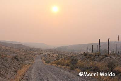
This morning's sunrise over Bates Creek
Inciweb had not been updated, so we drove back out to Murphy this morning. They're socked in with smoke too, but it appeared the fire line had indeed held, and we saw bulldozers and a plane out there working, and fire trucks headed out various roads toward the mountains where the heavy smoke was. So even with a strong north wind today, and the fire up to 277,000 acres (and only 15% contained), we're still in a safe spot, even with the closest moving fire edge 12-14 miles away as the Raven flies.

night view from west of Murphy… blurry from hand-held telephoto
It is somewhat maddening in this day and age of technology not to get updates (as of 2 PM, Inciweb said it was current, but the fire map had not been updated, and the news updates are old), but even more so for those nearest the fire and on the edge of evacuating.
We've been offered help in the form of trailers, help moving and driving, and places to board horses by so many people, and for that we are grateful. Now - we just sit and wait.


smoky day up the crick. eyes and lungs burn just standing or sitting around! good day not to ride
Here's a slideshow of pix from last night:
or a link to the album.


